ALP.Lab: UHDMaps(R) for Simulation and Beyond
April 16th, 2021 | by Marius Dupuis
(5 min read)

We are continuing our series on stakeholders with an example from Austria. On March 18th, 2021, we had a chance to talk to ALP.Lab, located in Graz, Austria. ALP.Lab is an innovation laboratory for the testing of autonomous mobility solutions. They provide their services to industry and national research teams and also offer a marketplace for data and services which are required for other teams conducting research for mobility. ALP.Lab’s shareholders are industry and research entities in Austria, and they also receive support by the respective ministries. One of their key research partners, JOANNEUM RESEARCH, participated in our discussion.
Our interest in talking to ALP.Lab originated from an announcement by them of the availability of UHDMaps(R), a trademark owned by JOANNEUM RESEARCH. And it turned out that many of the ideas presented in Our Mission have also made it independently into their portfolio.
Data Acquisition
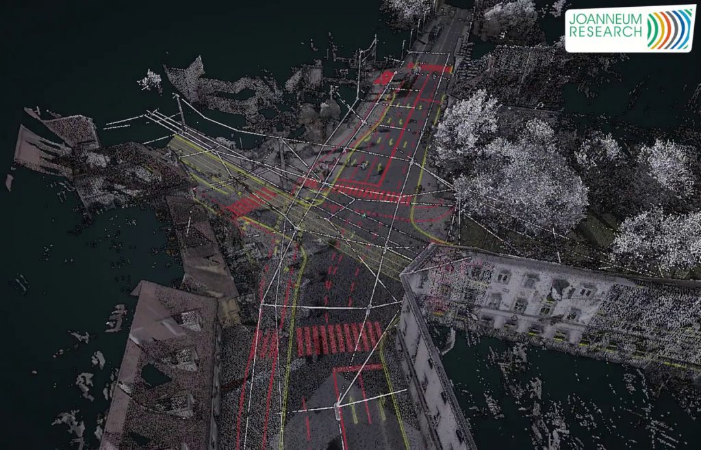
If you measure, do it right. JOANNEUM RESEARCH has come up with a process of performing highly accurate measurements of a test region in the greater Graz area. Their sensor set is based on but not limited to highly accurate GPS, camera and LiDAR technology. Measuring is performed with a dedicated vehicle that acts as carrier of the equipment. ALP.Lab also have a partnership with the road authorities in their region, so that lanes can be blocked for other traffic during a measuring campaign.
The measuring does not necessarily concentrate on a single purpose. Sensors are set up in a way that, for example, road layout data can be derived as well as road surface data. The idea of the digital twin whose data lake provides information for various use cases is very well incorporated into the process.
Data Processing
Accuracy is a crucial issue, especially if you want to distinguish UHDMaps(R) from HDMaps (see next section). In order to calibrate their measurements, JOANNEUM RESEARCH have access to fix points along their tracks. Lately, they also started to improve calibration in urban environments where you would usually not experience the same quality of sensor data (e.g. from GPS or by ghost objects) as you do under open motorway conditions.
The actual calibration process (see also this paper – in German – by JOANNEUM RESEARCH) starts with the determination of the exact vehicle trajectory. For this, they use GNSS, IMU and odometry data with GNSS information of the base stations allowing for “differential GNSS” calculation. Additional accuracy is achieved by performing forward and reverse application of odometry data along the trajectory. The resulting data are validated with the previously mentioned control points that have been measured independently.
The system is calibrated in order to retrieve precise trajectories from the initial data. After this step, you start cleaning the data (e.g. from ghost signals of the LiDAR – an effect seen in particular at traffic signs). Next, you can start describing them semantically. This process is initiated manually in a small region, so that the algorithm used later-on in the process has an exact blueprint for the correct categorization of elements. Afterwards, the annotation is applied at a larger scale using automated methods with optional manual support.
Speed of data processing and quality assurance have to be matched. Despite some tooling available on the market, JOANNEUM RESEARCH in collaboration with the Technical University of Graz have come up with their own tool set to process (classify, extract, store) the measured data and perform a statistics-based manual validation of the resulting UHDMaps(R). By this, they have all stages under control, can adapt quickly to their requirements and know the quality and origin of each data point.
The Product
The result of the previously described efforts is a UHDMap(R), a map that provides absolute single-digit centimeter accuracy across all features that it represents. The maps are stored in a way that comes close to what we call the data lake. The internal format takes into account – and extends – the rules set by our authors Andreas and Michael (see About Us) in a project called Road2Simulation.
From the data lake, the data can be exported by JOANNEUM RESEARCH into various target formats, among them being the ASAM standards (OpenDRIVE, OpenCRG) and various simulation vendors’ custom formats.
UHDMaps(R) are considered a good fit for an automated driving system’s validation process that may incorporate simulation solutions but also real-world tests on the respective roads. They are not optimized for commercial use in, for example, a head-unit in an actual vehicle.
Next Steps
Keeping the Data Up-to-Date
Everything changes. Even complete continents are shifted by earthquakes once-in-a-while. The changes of the surveyed road networks are usually not that dramatic but over time there is wear and tear on everything and road marks might get repainted, signs exchanged, pavements redone etc.
It would be a tremendous effort and a hardly scalable process to measure everything again and again with the same sensor sets and sensor carriers. Therefore, ALP.Lab is looking into methods for reducing costs on the sensor sets and their deployment. One strategy is to use a lower-grade sensor set and do the data matching based on the validated original map. This will give a set of deviations that represent changes in the real instance of the environment and that have to be incorporated into the data model.
Another possibility in the future might also be to “crowdsource” the data of the real environment by accessing measurements from a larger number of regular vehicles, all equipped with ADAS sensors. ALP.Lab assumes that a large enough number of measurements will give highly redundant information whose accuracy can be increased by matching them with the original, validated map.
Dynamic Content
Everyone talks about “scenario-based testing” and tries to incorporate this approach into their development process. The scenarios may come “for free” while you are performing your measurements or by using fixed-base sensors at locations in the real-world for which you also have an UHDMap(R) at hands.
With these additional, time-variant data points in the measurements, ALP.Lab can extract the relevant data from the underlying map and create scenarios from them. Their sensor setup also covers longer stretches of tracks, e.g. by fusing the data of a sequence of fixed-base sensors, so that they may even derive complex scenarios that stretch over some time and distance. Categorizing and parameterizing these scenarios (as is required for the full flexibility of scenario-based testing) is another story, still.
No matter how you put it, going from static to dynamic is a natural choice and may only increase the number of applications for the original maps. ALP.Lab is following this path.
Sensor Simulation
The original measurements not only allow to derive and categorize road elements but also to collect data on infrastructure and surrounding objects. At minimum, measurements are taken by camera and LiDAR sensors and JOANNEUM RESEARCH already uses a RADAR 77GHz RAW Data Sensor calibrated with their mobile mapping system to produce georeferenced RADAR map-layers with 10cm resolution. This means that the raw data of a measurement campaign will provide you with loads of information how a sensor with a given technology perceives various kinds of objects. If you keep this information in your data lake, it will be an excellent basis for developing, training or verifying sensor simulation models.
Just imagine what value, for example, a geo-referenced RADAR map will have for someone who is in the process of validating their RADAR sensor model. All it would take is the attributed UHDMap(R) and a short trip to wonderful Graz with the real sensor mounted to the vehicle for verification. Not because you wouldn’t be able to do it based on the map alone, but because Graz is always worth seeing.
Summary
From data acquisition via data processing to keeping a data lake and having the right tooling at hand – ALP.Lab is an excellent blueprint for what it takes to act as GEONATIVES in this world. Thanks again to their team for giving us a deep insight into their business!