Our Mission
March 30th, 2021 | by GEONATIVES
(4 min read)
Mobility comes in various formats: on the road, in the air, on the rivers, and on rails – just to name a few. It is targeted either for commercial transport, for commuting or for leisure. And it is changing continuously. Not only did civilization move from the horses that once set the pace of traffic within limited range to high-speed links between urban hubs, countries and continents; today’s shift is a rapid transition from the concept of individual human-controlled participants to a fully connected ecosystem that encompasses to a large extent automated and autonomous entities. We are witnessing a fundamental change of the game.
And this game is data-driven. Any advanced mobility concept relies on data about the environment within which it is acting – either as data collected up-front (e.g. maps) or as data entering the system on-the-fly (e.g. from sensors). Together, these data provide a digital replica of the world which they were collected from. And they do so for a given time, a given region and a given purpose only.
The number of stakeholders participating in this game is rising. Public authorities and infrastructure operators are joined by vehicle manufactures, fleet operators, mobility-as-a-service providers and logistics companies as well as society itself with the interest in contributing to and participating in decision making. Some of these stakeholders already operate data lakes and a lot of them are generating new ones.
This is a problem; the world out there comes as a single, discrete entity but its representation in terms of data comes in innumerable variants – sometimes for the same purpose. The idea of creating a digital twin of the world that can be used for enhancing mobility is stuck in the swamps of multiple, inconsistent representations of small fractions of it for targeted purposes only.
It’s time for us, the GEONATIVES. Our mission as a think tank is to dry the swamp of data flows, data formats, tooling etc. and make it viable for efficient collaboration among the interested parties. To be honest, completely drying the swamp is near-impossible and might even not be necessary. But we can start by building paths across it that will help you navigate – and use – the possibilities efficiently.
So much for our motivation and the nice words and pictures around it. Here come the facts:
Our credo: A single world that is being navigated in different ways shall be represented by a single digital twin that can be conditioned for different target applications.
This implies the following:
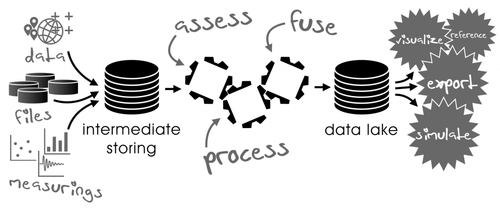
- The digital twin is built with data from various sources (e.g. surveillance agencies, municipalities, vehicle sensors) in a consistent way.
- Data are held, transferred and assessed using well-defined, publicly accessible data formats.
- Data are processed and fused in order to derive new information based on the collected data.
- The digital twin is stored as a data lake that accumulates the refined data.
- The data lake is managed; it is checked and rated for data quality and data consistency.
- Validated toolsets provide means to import and export data, to query the data lake and to assist in its management
- The digital twin serves all stakeholders – industry (e.g. automotive, railroad) offering products and industry offering services as well as governmental agencies (e.g. municipalities, authorities), academia and society – for an exhaustive set of applications.
What role will the GEONATIVES play?
First, we have a strong background in collecting, conditioning and using geo-correlated data for various purposes. Among these are environment simulation solutions, data linkage and management, highly accurate road description, fusion of heterogeneous geodata and the urge to leverage synergies.
Second, we have seen many data sets that were collected for identical locations and almost similar purposes in inconsistent ways. And we have seen data that have already been made available for one purpose as being a good fit for other purposes, too; but a lack of awareness of these existing data led to additional data acquisition campaigns.
And, third, we have seen many parties struggling in their endeavor to keep data up-to-date, exchange them between applications, rate their quality etc.
If mobility is to become a true driver of our future, the item that drives mobility – data – has to be handled in a way that provides scalability and reliability at commercially beneficial terms. Indicating a path to this goal is our mission.
We will use this blog to discuss various aspects of earth’s digital twin with respect to mobility in a regular fashion. The five pillars of our project will be:
Each blog entry of this think tank will concentrate on one (or more) of these pillars (while indicating correlations to the other pillars) and we will report our personal vision, interviews and articles with domain experts, links to correlated articles on the web etc. We will try to address the issues that adversely affect a growth in data handling productivity.
You will read our opinions based on what we know, what you let us know, what we discover and what comes to our mind when reflecting on tomorrow’s world.
We act independently out of our own motivation and we spend our own time on this think tank. Earth is unique and challenges to mobility are diverse. Someone has to think about proper alignment. Because it has to be done.
Considering the enormous challenges it seems to be a Sisyphean task. There are plenty of things to be considered which are not simply discrete but variable in more than 4 dimensions. Taking into account all the parameters from environment conditions, variations over time, varying sensor demands and a lot more it needs the expertise from many research areas to make a future-proof representation of the virtual world.
For me a good approach could be an “OpenData” project where experts from different areas share their know-how like it was done for other “OpenXXX” projects. The seed of such an idea seems to be very promising both by the people involved and also by the approach to topics which are not well covered by existing data representations. The virtual world representation should be driven by technique and not be related to political interests or unsuitable existing implementations. The format should be capable of covering the whole world as well as variations over time and due to varying demands.
As the world is changing quickly an automated data acquisition has also to be considered to feed and update such a database. This is crucial because the only way to do this is using the existing sensors of traffic vehicles which are available in large numbers but with a low fidelity. Considering the amount and complexity of the collected data as well as the necessary processing capability to generate updates there are more problems to solve than the data privacy issue.
As autonomous driving will rely on these data it must be also assured that changes in regulations or driving algorithms will be compatible with the database and progress is not obstructed by inflexible data representation.
So my recommendation is: Start working before the future is past.