Expert Interview: Looking Across the Great Wall
July 4th, 2022 | by GEONATIVES
(5 min read)

In this interview, we were asking Li Qingjian of China Dayou Positioning Intelligence Co., Ltd. a few questions on mapping and digital twins in China. His answers provide good insight in the business on the far side of the Great Wall. This interview is also a first – it’s provided in both languages, English and Chinese.
Li Qingjian, thank you very much for taking the time to answer a few questions for the blog of our GEONATIVES think-tank. In your role as Vice President and CTO of China Dayou Positioning Intelligence Co., Ltd, you are definitely one of THE experts on maps and mobility in Greater China. Would you mind introducing yourself and your company to our readers? (介绍我和我的公司)

李庆建 国汽大有时空科技有限公司 副总裁,中国智能网联汽车产业创新联盟自动驾驶地图与定位工作组副组长;中国汽车工程学会高精地图与定位专家;原国家智能网联汽车创新中心高精地图定位负责人; 毕业于武汉大学,多年从事导航地图及高精地图和定位等领域研发、产品经历,具有较强的软件研发和产品设计经验,具有多项专利,参与多项省、部级高精地图项目研发。
I am the Vice President of China Dayou Positioning Intelligence Co., Ltd, Deputy leader of automatic driving map and positioning working group of China Industry Innovation Alliance for the Intelligent and Connected Vehicles; expert of high precision map and positioning of China Society of Automotive Engineering; former head of high precision map and positioning of National Intelligent Networked Vehicle Innovation Center; Graduated from Wuhan University, I have been engaged in the R&D of navigation map and high precision map for many years, I have also strong experience in software development and product design, written a number of patents, and participated in the development of multiple provincial and ministerial high precision map projects.
How do you see the business landscape for digital twins (i.e., maps and environment models) in China? To what extent is technology sourced and applied within China?
你如何看待中国数字孪生(即地图和环境模型)的商业前景?技术在中国的来源和应用程度如何?
中国数字孪生商业具有巨大的商业前景;首先,中国经过20多年的发展,在地图数据产业有多家数据服务公司,拥有地图资质,并拥有全国精细的地图数据,并形成了数据采集制作应用的数据产业链;其次,中国巨大的市场空间,基于地理信息应用行业,规模及应用研发能力巨大;形成了2B及2C的巨大商业应用市场;第三;中国基于政府及事业单位的数据管理服务单位,具有测绘专业的地图数据,应用规划及自然资源管理,尚待进一步释放产业应用能力;
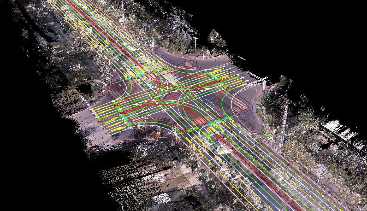
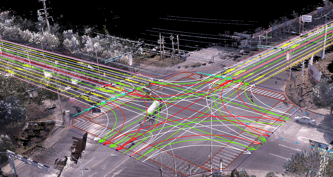
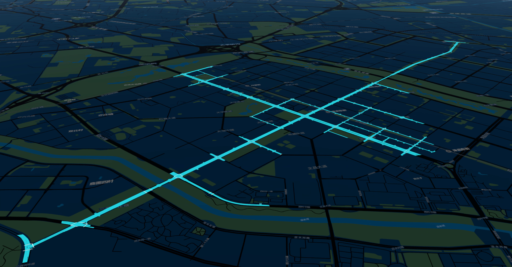
当前阶段,中国数字孪生地图技术,已经日趋完善,并能与国际地图技术能力差距不大;已经形成地图数据获取及制作能力;在传统产业应用上已经初具规模及达到应用能力;但新型产业包括数字孪生结合新的应用上,尚待挖掘,或尚需验证; 尚未就地理信息与数字孪生应用上形成规模、深度、专业的应用;当前技术仍更多停留在数据采集制作及可视化及基本的计算辅助工具上;新的数字孪生应用领域规模化尚没有形成。
China’s digital twin technology has huge business prospects. First of all, a number of map data companies have emerged in China with map qualifications in the map industry after more than 20 years of development. They also have national dedicated map data and have formed an industry chain of data collection applications. Secondly, due to China’s huge market space, the scale and the R&D capabilities in the field of geographical information application have increased, which further formed a huge 2B and 2C commercial application market. Thirdly, China’s data management service enterprises based on the government and public institutions are provided with professional mapping data, application planning and natural resource management, which need to be further released.
At the current stage, China’s digital twin map technology has become increasingly perfect, gradually narrowing the gap with international map technology capabilities. Map data acquisition and production capabilities have been formed. It has begun to take shape in the traditional industrial applications and achieved application capabilities, but the new industry includes digital twins with new applications, yet to be tapped, or to be verified. Geographic information and digital twin applications have not formed large-scale, deep and professional applications. The current technology is still stuck in the data acquisition and visualization and basic computing tools. It can be seen that the scale of the new digital twin application field has not yet been formed.


In a huge country, planning, building, surveying, and updating traffic networks is a major task. In Europe and in the US, we see technologies emerging where regular vehicles with an ADAS or autonomous driving sensor set may be used as sources for creating the “data lake” and keeping it up to date. Also more and more companies utilize crowd-sourced data from citizen such as OpenStreetMap. What strategies and technologies do you see in your country?
在一个大国,规划、建设、测量和更新交通网络是一项重大任务。在欧洲和美国,我们看到一些技术正在兴起,带有ADAS或自动驾驶传感器组的常规车辆可能被用作创建“数据湖”并保持其最新状态的来源。此外,越来越多的公司利用来自公民的众包数据,如OpenStreetMap。在你们国家,你们看到了哪些战略和技术?
中国目前也认识到了基于地图数据的交通基础设施数字化服务的重要性,也形成地图领域、交通领域、汽车领域各自的数据服务商;基于ADAS 或自动驾驶汽车数据众包也是未来发展的趋势;
但基于国家政策资质的管理,数据制作及生产是少数具有资质的企业;因此 基于众包数据技术路线虽然是大家研究的重点,但尚不能市场规模化使用;
但拥有资质的企业,完全具备众包数据的能力和技术,以及市场应用能力;随着政策资质的完善,已经商业化落地的推动,会有进一步发展;
中国的数据厂商,往往也是数据服务提供商 ,同时也是数据应用使用方;因此 未来数据使用领域 包括智能网联汽车、智能交通是数据整合的关键;同时也是当前企业技术战略的重点,比如智能网联汽车领域的发展。
China has also recognized the importance of digital services for transport infrastructure based on map data and has formed their own data service providers in map, transport, and automobile fields. Crowdsourcing of data based on ADAS or autonomous vehicles is also a trend for future development, but based on the management of national policy qualification, few qualified enterprises are allowed to product data. So based on crowdsourcing data technology is the focus of everyone ‘ s research, but can’t be widely used in the market.
On the other hand, qualified enterprises are fully equipped with crowdsourcing data and technology, and market application abilities. With the improvement of policy qualification, the promotion of commercialization will be further developed. China’s data manufacturers are often data service providers and data application users; therefore, future data use areas including Intelligent and Connected Vehicle, intelligent transportation is the key to data integration; at the same time, it is also the focus of current enterprise technology strategy, such as the development of Intelligent and Connected Vehicle field.
Which user groups of geodata do you see in your business and how compatible or diverse are their requirements when it comes to the idea of aggregating geodata in generic “lakes” and extracting relevant sub-sets for certain user groups?
在您的业务中,您看到哪些地理数据用户组,以及当涉及到在通用“湖泊”中聚合地理数据并提取特定用户组的相关子集的想法时,它们的需求有多大的兼容性或多样性?
在我们相关领域中,数据湖的应用,是在不同行业具有不同的发展阶段;当前发展比较成熟的是汽车导航地图数据领域;随着汽车领域、手机领域等用户对地理信息数据的应用日趋规划,已经形成完善的技术及数据标准;
但在传统规划及相关领域,仍具有地域特性,各个应用存在使用各地方数据,虽然也有一定的标准及规划,但仍然有地域特点;
所以,数据的需求取决于应用领域市场,或领头企业的应用领域集中程度,其往往 也有地图资质,也具有巨大数据资源,或成为数据湖;
In our related fields, the application of data lake has different stages of development in different industries. Vehicle navigation map data is maturely developed. With the automotive and cell phone field and other users of geographic information data applications increasingly planning, has formed a perfect technology and data standards. However, in the traditional planning and related fields, there are still geographical characteristics, and each application uses each local data. Although there are also certain standards and planning, there are still geographical characteristics. Therefore, the demand for data depends on the application field market, or the degree of concentration of application fields of the leading companies, which often also have map qualifications and huge data resources or become data lakes.
Today, we see that many companies measure the same areas again and again (just think of all the digital twins of San Francisco’s traffic network). With a more centralized planning, we would assume that redundancies can be minimized, and the use of resources can be optimized. Is it correct to assume that in China data collection and processing are managed more efficiently?
今天,我们看到许多公司一次又一次地测量同一地区(想想旧金山的交通网络中所有的数字双胞胎)。通过更集中的规划,我们可以假设冗余可以最小化,资源的使用可以优化。假设在中国,数据收集和处理的管理效率更高,这是正确的吗?
中国采用的地图数据采集及制作资质的管理办法,但并不限制采集的范围,因此,已经形成若干家家具有全国数据采集及制作能力的公司;通过集中规划,统一采集,不利于市场化竞争,也不利于技术竞争发展;
虽然未来智能交通及应用领域技术的发展,会需要数据标准及规划的统一,甚至是众包数据的统一,但大概率会是市场的竞争的需要,从而需要完成数据的统一;
The management of map data collection and production qualifications adopted in China does not limit the scope of collection, so several companies with national data collection and production capabilities have been formed. Centralized planning and unified collection are not conducive to market competition, but also to the development of technological competition. Although the future development of intelligent transportation and application technology will require the unification of data standards and planning, and even the unification of crowdsourcing data. But it will be the need of market competition, so as to complete the unification of data.
Reality is more-or-less available to everyone. But who owns or should own the digital twin of reality? What is your experience in terms of data ownership?
每个人都或多或少地了解现实。但谁拥有或应该拥有现实的数字孪生兄弟呢?您在数据所有权方面有什么经验?
数据采集及制作,未来将是 静态数据制作厂商和基于众包数据的服务商合作,形成未来数字孪生数据能力; 掌握众包技术的应用市场能力具有更多的能力,拥有数字孪生数据;
数字孪生的技术能力不取决于数据采集制作能力,而取决于产生数据的应用厂商,取决于拥有物联终端服务能力,取决于物联世界动态数据获取能力;
Data acquisition and production will be the cooperation between static data manufacturers and crowdsourcing-based service providers to form future digital twin data capabilities. Mastering crowdsourcing technology application market capabilities requires more capabilities with digital twin data. The technical ability of digital twinning does not depend on the ability of data acquisition and production, but depends on the application manufacturers that generate data, the ability to have the Internet of Things terminal service, and the Internet of Things world dynamic data acquisition ability.
We are aware that geodata sourced in China is not supposed to leave the country and that any data available publicly may have offsets applied to geo-locations. This seems to make sharing of data, e.g. between surveying companies and users, somewhat of a burden. But, maybe, we are missing the big picture. When working with geodata, what policies and/or restrictions do you have to consider if you are trying to share data among various stakeholders?
我们知道,来自中国的地理数据不应离开该国,任何公开可用的数据可能会对地理位置进行偏移。这似乎使数据共享(例如,调查公司和用户之间)成为一种负担。但是,也许我们错过了大局。当使用GEATDATA时,如果您试图在各利益相关者之间共享数据,您需要考虑哪些政策和/或限制?
首先,提供数据共享,需要测绘资质,需要具有相应数据安全能力;政策上需要资质及数据管理安全上的体系;
汽车,确保共享数据及各利益相关之间 数据应用过程的数据安全;
First of all, to provide data sharing, it needs surveying and mapping qualifications and corresponding data security capabilities. From national policy side, it needs the system of qualification and data management security. The car side needs to ensure data security for shared data and data application processes between stakeholders.
Centrally held data lakes may be made available for a large range of use cases (traffic planning, routing, infrastructure planning and maintenance, municipal administration etc.). According to our credo, the incorporation of standards into the data pipeline will facilitate data re-use. Which standards (e.g., for data formats) do you see as relevant in your business domain?
中央控制的数据湖可用于大量用例(交通规划、路由、基础设施规划和维护、市政管理等)。根据我们的信条,将标准纳入数据管道将促进数据重用。您认为哪些标准(例如数据格式)与您的业务领域相关?
目前交通规划及基础设施的规划和维护、市政管理等应用仍然掌握在各地方事业单位中,一般市场单位尚获取不了该应用领域的市场应用;具有更严格标准及统一性及数据安全管理;
我们应用领域在智能交通及智慧化应用数据服务领域;在智能网联汽车、汽车导航、智能交通、数据仿真等相关格式标准与我们业务领域相关。
At present, traffic and infrastructure planning and maintenance, municipal management and other applications are still mastered in local institutions. The common enterprise can not obtain the market application since there are stricter standards and unity and data security management. Our application field is in intelligent transportation and intelligent application data service; Our business areas are related to Intelligent and Connected Vehicle, vehicle navigation, intelligent transportation, data simulation and others.


Looking at mobility solutions: how would you summarize the state of the “mobility sector” in China. How, for example, do you see the maturity of “multi-modal transport solutions” (i.e. using public transport of various kinds – plane/train/metro/bus/minibus/scooter – up to the last mile)?
关注移动解决方案:您如何总结中国“移动行业”的现状。例如,你如何看待“多式联运解决方案”(即使用各种公共交通工具——飞机/火车/地铁/公交车/小巴/滑板车——直到最后一英里)的成熟度?
物流领域是中国较为发达的应用领域,也具有若干家较大的企业,一般是自建机场或物流车队等专业物流园区;形成全国规模的快速物流;该企业也具有地图测绘资质,具有数据采集及制作能力;应用比较成熟;
但仍然有更多 航空及物流园区、港口、铁路等多式联运,尚处于未开发数字孪生地理信息锲合的应用;有很大的发展空间;但往往各个环节数字化应用能力不完善,形成地理信息数字化服务应用具有较多的困难和巨大的工作。
The logistics field is one of the developed application areas in China. Some of the large companies are building their own airports or logistics fleets and other professional logistics parks thus forming a fast logistics on a national scale. This enterprise also has mapping qualification, with data collection and production capability. But there are still many aviation and logistics parks, ports, railroads, and other multimodal transport still in the application of undeveloped digital twin geographic information wedge. These enterprises have a lot of room for development. However, due to the imperfect digital application capability of each link, it is a very difficult job to form the digital service application of geographic information.
What role will highly automated driving play in the future of China’s mobility sector? Will it be limited to road applications or will other transport means, for example trains or river traffic, also be fully automated?
高度自动化驾驶将在中国交通部门的未来扮演什么角色?它将仅限于道路应用,还是其他交通
自动化驾驶,在中国交通未来发展,已经成为共识的发展,但尚不具备大规模商用化条件,仍然在研发测试示范应用的基础上;
自动化驾驶未来不仅仅是限于道路应用,更多场景包括园区,或更多空间会使用,自动驾驶将成为各行业应用发展的趋势;建立以自动驾驶移动载体的商业应用是未来发展;
在火车 高铁领域,中国已经完成自动化;河运 由于市场规模或应用限制,尚没有大规模的自动化技术投入;
Automated driving has become a consensus development in China’s transportation, but it can’t be widely used in the market and is still at the stage of developing test demonstration. The future of automated driving is not limited to road applications, but more scene applications including parks. It will become the trend of application development in various industries. The establishment of commercial applications with autonomous driving mobile carriers is the future development trend. In the field of train and high-speed rail, China has completed automation. There is no large-scale investment in automation technology in river transport due to market size or application constraints.
To what extent will the infrastructure and regulations need to be modified in order to enable autonomous mobility solutions? Will these adaptations make it easier to develop devices (e.g., vehicles) that may operate in the new environments? Or, asked in a different way: will infrastructure adapt to mobility solutions or vice versa?
为了实现自主移动解决方案,需要在多大程度上修改基础设施和法规?这些调整是否会使开发可能在新环境中运行的设备(如车辆)变得更容易?或者,用另一种方式问:基础设施会适应移动解决方案吗?反之亦然?
为了实现自主移动解决方案,相关政策及法律正在完善,牵涉多家部委及多个法律; 根据自动驾驶产业的发展及推动,相关法律修订也提上了日程;法律法规的完善,将会对现有自主移动解决方案提供规模化应用便利;同时,各基础设施的规划及服务应用,给移动解决方案提供便利;当前基础设施的新的规划及应用会适应移动解决方案,将会带给自主移动解决方案更为发展快速。
In order to achieve autonomous mobility solutions, relevant policies and laws are being improved, involving multiple ministries and laws; according to the development and promotion of autonomous driving industry, the relevant laws are also put on the agenda. The improvement of laws and regulations will facilitate the large-scale application of existing autonomous mobility solutions. Meanwhile, infrastructure planning and service applications facilitate mobility solutions. The new planning and application of current infrastructure will adapt to mobility solutions, which will bring more rapid development of autonomous mobility solutions.
Final question: What topics would you like to see covered in a blog like ours?
最后一个问题:你希望在我们这样的博客中看到哪些主题?
希望能看到更多的行业应用领域、数据标准、基础设施技术方案等应用更多案例
I hope to see more industry applications, data standards, infrastructure and other application cases covering in the blog.
Thanks a lot, Qingjian!