Experts’ Voices: Getting Traction on Geodata
November 21st, 2023 | by GEONATIVES
(6 min read)
A ride on a German ICE train is the perfect setting for summarizing a great conversation with two experts from Deutsche Bahn (DB) Bahnbau Gruppe GmbH and DB Engineering & Consulting GmbH about the digitalization of the DB infrastructure. On June 21st, 2023, we had the pleasure to talk to Albrecht Vaatz and Peter Holzberg about their vision and mission.
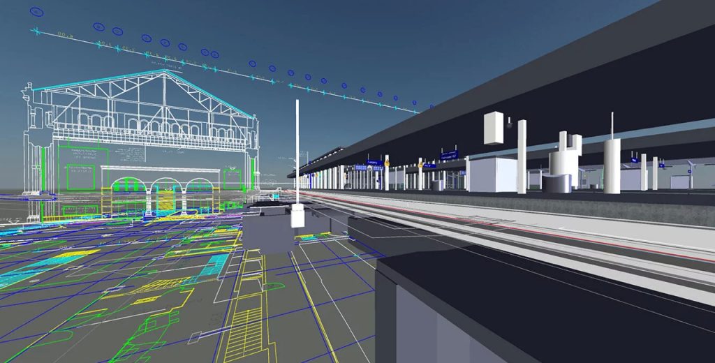
The central aspect of their endeavor is the so-called Building Information Modeling (BIM), a methodology enabling efficient construction and maintenance of e.g., buildings and built infrastructure such as bridges and signal gantries by using digital twins, and providing everything for the full lifecycle management of infrastructure. BIM itself is part of the so-called “Digitale Schiene Deutschland” (digital track Germany) strategy of DB. From 2025, all of DB’s planning and execution of construction must be based on BIM.
Albrecht, a construction engineer with a strong background in steel bridges for railways, is fascinated by the question how planning, design and construction can be executed fully in digital 3d environments in the future and what kind of data acquisition, consistency check, versioning and provisioning processes are necessary. The playground is quite large because the concept should not only work for single locations but across the entire 33 thousand kilometers of railroad routes (each consisting of one or more parallel tracks).
“Just do it”, one might be tried to say. But there’s more than only a single devil in the detail. As Albrecht is focusing on bridges, he needs more information than what might be covered by (digital) data on tracks and signals (so-called “IVL” and “IVG” information). He will also need spatial contours in the vicinity of the actual tracks. Available construction and planning data often lack quality and are outdated, and have to be smoothed by the consumer because the planners consider their job already done.
And here we are right in the heartland of GEONATIVES. Albrecht’s vision is a centrally maintained database comprising all information that has been and will be collected about DB’s infrastructure. These data may be used for planning the construction of new elements, maintenance of existing ones, electrification of tracks (yes, even in Germany, a substantial stretch of tracks is “for diesel only”), upgrades of signaling systems (e.g., to computer-based interlocking such as ETCS) etc. And his first task is to make sure that data get into this pool to have the track as digital twin available for all the examination and planning tasks.
The digital twin should consist of various data but shouldn’t be merged into one model. It is more useful to link layers and only access them if they are required. It makes the data also more interoperable to not have them in one world-formula format. The requesting use cases will specify the level of detail of the collected data.
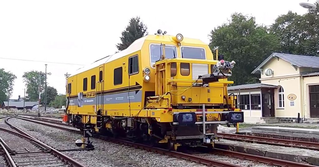
To collect fresh and precise data is where Peter comes into play. DB E&C is the company that pre- and post-processes the data collected by DB Bahnbau Gruppe which, itself, is executing the actual surveillance jobs and providing the panoramic image, LiDAR point cloud, and even ground-penetrating radar data that go into the system. With the help of the sensor setup they are able to provide a 360° view from the track since mid of 2021 (hence the name of their core product: “360° multisensor platform (MSP)”). The MSP team was able to establish an official cooperation between the two DB houses in 2023. Their key challenge is to mitigate accessibility problems of tracks for running data acquisition equipment on them. With an ever-increasing traffic density on German railroads, it is hard to run a (rather slow) measurement trainset in-between other trains or even having stationary surveying. Therefore, aerial surveillance and data acquisition by drones are two additional means. For processing and working with the collected data, but also for distributing the post-processed data of any of these sources, DB E&C brings a data platform with an integrated viewer into the cooperation.
What always puzzles us is the question of data quality. You can measure a lot and the numbers may look nice. But making sure that they are all consistent is a different story. And the same applies to the data collection for BIM. First comes the consistency of the data, which is currently checked in a mainly manual process (marketing departments would call it euphemistically “semi- or partially-automated”).
Another step is the spatial positioning of data. For this reason, target plates (as reference points or ground control points) are placed along the tracks, which are large enough to be hit by a sufficient number of LiDAR rays so that they can be aligned in the post processing or used for accuracy checks.
Accuracy of data points in 3d space is currently achieved in three levels: less than 1 m (level 1), less than 20 cm (level 2), and less than 5 cm (level 3). Level 3, though, will require reference targets approximately every 50 m (which is a considerable but not unmanageable challenge since masts for the catenary typically bear reference indicators, so-called “Gleisvermarkungspunkte (GVP)”).
The anonymization of data and the homogenization of point clouds, i.e., combining point clouds from multiple runs along parallel tracks into a single ground truth, are two other steps that we briefly talked about.
And, yes, there’s also the topic of versioning. We didn’t have a chance to go deeper than just mentioning it but for interested parties, the EC-3 Conference (Paper “Integration of semantic temporal information in BIM using ontologies”) may provide more information.
Room for synergies
Most of these topics sound familiar to you from our previous blog posts? And from other industries, too?
Well, frankly speaking, we could literally feel in our interview Deutsche Bahn’s focus on their tasks. It wasn’t like a “not-invented-here-culture”, and both Albrecht and Peter are clearly not the guys who wouldn’t want to use synergies with other industries. And, clearly, they have invested considerable time in getting a first overview of available technologies. But we would have wished for DB to have a much closer look at, for example, the automotive industry with all its data collection and processing tools for highly automated driving. Nevertheless, it is important to keep in mind that every domain has their specific exceptions and therefore approaches can’t be adopted seamlessly. Learning from each other’s requirements will help both parties.
Clearly, DB has its own geo-reference system (“DB_REF”, EPSG:5681) but if the real world fits into this system and fits into other systems as well, we would boldly assume that there should be a way of transferring data from other sources into DB_REF instead of having to measure everything uniquely (and again?) in that system. As Albrecht explained, the own reference system was defined to overcome issues with cross-border projects and various height reference systems. By this, construction projects, which cover hundreds of kilometers, can still achieve millimeter accuracy.
But, honestly, the task of digitalizing tracks is a huge one, and, as the saying goes, if you want to go fast, go alone. The railway domain is sometimes an ecosystem on its own, struggling with heterogeneous analogue and digital infrastructure that cannot be replaced in one knee-jerk action. Digital trends are often adopted step by step and currently mainly driven by GIS tooling from cadastral domain, which get adapted for railway domain instead of utilizing latest tech from automotive or aerospace domain. But shouldn’t other industries benefit from data of DB, too, especially in areas where there is an overlap? Just think, in the simplest case, of railroad crossings, container hubs with automated logistics and train stations, where different modes of transport meet. Utilizing third-party data from other surveillances could help but can also add more inaccuracy to the data, if you can’t spend time on adequate import and fusion of these data.
This exposes two more issues: data security is highly important since DB is part of Germany’s critical infrastructure, and therefore, not all data can be made available in general. Data is provided if there is a legitimate interest, which gets approved by the German state, the German federal states and affected municipalities. As is the case with many administrative processes, also this procedure leaves considerable room for improvement regarding required data and level of detail. Customers for these data are the second issue. Only if people are aware of the great asset that is currently being built up and have a means to access, convert, and process it for their purposes, will there be an overall benefit.
What Albrecht and Peter are doing sounds like a Sisyphean task. But we hope that, ultimately, they will succeed and create a blueprint for a data pool that pretty much reflects what they have been postulating for more than four years and we as GEONATIVES have been postulating in our blog for over two years now. We hope that this post will help them spread the word about their efforts not only among our readers but also in the ecosystem of Deutsche Bahn because there are a lot of stakeholders within the Group that could utilize their data as well.
Thanks to Albrecht Vaatz and Peter Holzberg for the very friendly and open conversation. We really enjoyed it!