Experts’ Voices: There’s more than 15 Minutes in one Hour
June 20th, 2023 | by GEONATIVES
(6 min read)
On February 13th, 2023, we had the pleasure to talk for more than an hour to Daniel Krajzewicz, researcher at German Aerospace Center (DLR), Institute for Transport Research, in Berlin. Having known him for many years, there were plenty of subjects to talk about. Ultimately, we decided to take a deep dive into one of his latest research topics: The 15-minute city.
This is currently a hot topic in traffic policy and different stakeholders in research and planning domain are working on tools and solutions.
Urban planners aim to design cities in a way that everything that is deemed necessary for daily life is within 15 minutes reach from an individual’s home. This includes shopping facilities, the workplace, schools, medical care, leisure-time possibilities etc. Primary means for transport are the bicycle and someone’s own feet.
Motivation
In Germany, the so-called “Verkehrswende” (mobility revolution) got stuck. Instead of scaling back on individual transport (read: motorized vehicles), more cars than ever are populating our cities. And they tend to get bigger with each generation. Where a compact car would have done in the past, the SUV is now the standard. This has an impact on the consumption of public space and overall emissions.
Some cities are fighting another trend: suburbia is getting stronger. With the recent pandemic proving the viability and flexibility of the home office, people who had a chance and could afford to leave the crowdedness of the city, moved into suburbs or to the countryside. Holders of white-collar jobs were definitely in a good position. This movement left business areas of cities considerably less frequented and rendered some infrastructure (including shopping facilities and the like) redundant.
But cities can only work efficiently at a certain population density and with public space not wasted. In other words: they have to be attractive places to work and live in.
What else is desirable for a neighborhood where everything is within reach and it takes no more than 15 minutes to get to all relevant locations? Wouldn’t it also mean that you finally had a chance to get to know the neighbors better and start to build a livable community? If you go about your daily affairs by bicycle or on foot (“per pedelec or per pedes”), you will certainly meet the same people frequently and you can start to build if not social relationships but at least a sense of community.
The Institute for Transport Research aims to analyze how far cities, e.g. Vienna, are in terms of becoming 15-minute-cities. Or to be more precise, an accumulation of 15-minute-municipalities within wider city limits. In German, there’s a nice word for this concept, which has been known since the old days in cities like Berlin and Hamburg: the “Kiez” (bluntly translated as “neighborhood”).
Modeling is key to success
The basis for the assessment whether an area qualifies as part of a 15-minute-city are accessibility measures. The standard approaches rasterize the area under consideration and measure various KPIs for each cell: distance to schools, shopping facilities, restaurants, jobs, parks etc. Currently, there is no or only a very limited intermodal model used. A full model would, for example, consider a short walk or ride to the next train station and then a bus transfer, another walk, or an electric scooter.
Today’s models concentrate either on one means of transport or on a fixed combination (e.g. bicycle + train). They also do not take into account that the actual demand and traffic flows have to be supported by external data sources or tools. They may neglect other aspects that may vary considerably over the course of a day, a week, a season etc.; just take the closing times of stores, for example, or that you choose a different transportation mode for bulk buying.
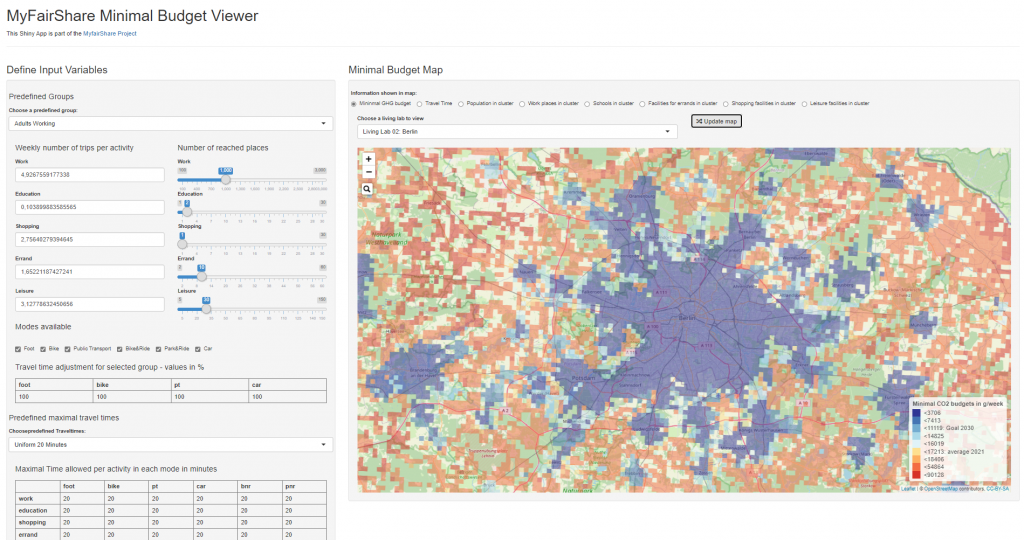
But what the models might consider are emissions. They are too crucial a factor in today’s cities’ management to be ignored. Therefore, the 15-minute-city may at some time also become an “emission budget city”, meaning that the main concern is how a city needs to be designed so that each individual’s daily commute does not exceed a certain emissions level. Again, an interesting way to look at things.
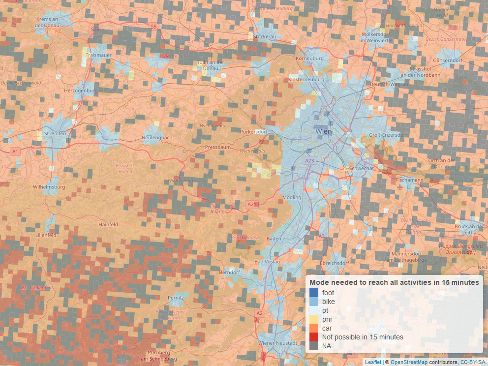
What Daniel and his colleagues came up with lately is a tool that is looking not only at cells within a rasterized area but at individual connections between source buildings and target locations. For buildings, they distinguish between different types. The key inputs to their model are OSM data and publicly available information about population density. For a complete assessment of an area towards the 15-minute-goal or x-ton-CO2-goal, they consider each transport means separately and compute all possible connections. This may take some time to compute.
The initial results, though, are within expectations: in terms of time and emissions, walking is good for short distances and a combination of bicycle and trains (e.g., local express trains) is good for larger distances. For high flexibility with short commute times, individual traffic (your own car) is hard to beat. But if you weigh the transport means for their (subjective) “ecological value” (walking on top, then bicycle, public transport and, finally, individual transport) you will get a clear shift.
More questions than answers
As already indicated, the models and tools are missing details. In our talk, we identified just a few which came to our mind: The average age of the population may influence not only the needs for facilities but also how far one can get within 15 minutes; weather and season will certainly have an impact on the selection of the transport means; jobs within 15-minute reach don’t necessarily have to be the jobs for the people who live within these 15 minutes; and many more. As usual, reality is more complex than models.
Another open question is, which CO2-budget may be deemed fair for an individual. This question goes beyond an even distribution across the population and would also need to take other economic factors into account (i.e. are absolute emissions per person sufficient or is it, for example, gross domestic product (GDP) per kg CO2 that a person is contributing to the economy?).
Current results
Overall, the results for today’s Berlin indicate that there’s still considerable room for improvement: as of now, the 15-minute-city is mainly a city of individual traffic either by car or, in the best case, by bicycle. The least can be done by walking and something in-between only using public transport.
Looking at the big picture of sustainability, three aspects need to be considered: efficiency, consistency, and sufficiency. Sufficiency has some potential to compensate for low efficiency but it all depends on what’s your basic measure (is it time, number of trips, emission etc.). No matter what: try to think of how you plan your own trips and what criteria you apply.
The 15-minute conspiracy
Now for the flip side: Does, as critics say, the 15-minute-city goal lead to ghettos? Or is this just a conspiracy theory (as so many things are these days)? It is neither. The 15-minute-city is an idealistic goal that provides the basis for analyzing a city’s performance and identifying weak points in transportation, accessibility etc.
In a municipal area that spans much further than can be reached within 15 minutes from end to end, there has to be a more or less continuous distribution of people and facilities. Therefore, achieving for each individual a 15-minute environment may, at best, lead to even distributions of key infrastructure instead of separate unconnected communities.
The only aspect that could interfere with this is the continued optimization of administrations by, for example, aggregating agencies across a larger area. This could, indeed, lead to certain “hotspots” on a map of public services within a 15-minute-reach.
Our conclusion
Overall, we see the benefits of aiming for 15-minute-cities: a reasonable and even distribution of services and facilities so that no individual is required to spend more of their precious lifetime to access everything that is needed on a daily basis.
Some of us GEONATIVES live in quite rural areas and small communities. And we cherish everything that is within 15-minute reach from home by walking or bike. But we are very well aware that everything else is at least an hour’s commute away.
Thanks, Daniel, for this inspiring talk!